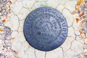
Today in history: United States Geological Survey created
![]() Although the rough geographical outlines of much of the American West were known by 1879, the government still had little detailed knowledge of the land. Earlier federal exploratory missions under men like Ferdinand Hayden and John Wesley Powell had begun to fill in the map, yet much remained to be done. The U.S. Congress decided to transform the earlier system of sporadic federal geological explorations into a permanent government agency and established the United States Geological Survey (USGS) on March 3, 1879, which played a pivotal role in the exploration and development of the West.
Although the rough geographical outlines of much of the American West were known by 1879, the government still had little detailed knowledge of the land. Earlier federal exploratory missions under men like Ferdinand Hayden and John Wesley Powell had begun to fill in the map, yet much remained to be done. The U.S. Congress decided to transform the earlier system of sporadic federal geological explorations into a permanent government agency and established the United States Geological Survey (USGS) on March 3, 1879, which played a pivotal role in the exploration and development of the West.
 From the beginning, the USGS focused its efforts on practical geographical and geological investigations that might spur western economic development. Since the vast majority of the nation’s public land was in the West, the USGS became one of the federal government’s most important tools for encouraging the exploitation of western natural resources. Congress appointed Clarence King, a young mining engineer and geologist, as the first director. King, who had previously done considerable work for western mining companies, viewed the USGS as a tool for aiding further mineral exploitation. As a result, the first major reports produced under King’s tenure concerned the economic geology of two important mining districts, Nevada’s Comstock Lode and Colorado’s Leadville silver district.
King’s attempts to aid western mining won him praise from both mining companies and western congressmen, but King was eager to make his own fortune in the mining business. He resigned as director in 1881 to pursue what he hoped would be more lucrative opportunities. John Wesley Powell, a bold geologist-explorer who had led the first American explorations of the Grand Canyon, succeeded King as director.
Powell extended the work of the survey into new areas like paleontology and soon became controversial for his bold assertion that much of the arid West would remain unsettled without large-scale irrigation projects. The direct and plainspoken Powell was so closely associated with the USGS during his 14-year term as director that many people have mistakenly believed he was the first director of the agency. Despite his expansion of the survey’s mission, though, Powell never abandoned the practical economic emphasis established by King.
Subsequent directors of the USGS also remained true to King’s early focus on aiding the economic development of the West, providing topographical and geological maps that have continued to prove essential to the mineral, agricultural and hydraulic development of the region to this day.
Today, the USGS is a scientific fact-finding research agency of the United States government — a bureau of the United States Department of the Interior with no regulatory responsibility — and is the nation’s largest water, earth and biological science and civilian mapping agency. It studies the landscape of the United States and collects, monitors, analyzes and provides scientific understanding of natural resource conditions, and the natural hazards that threaten it. Headquartered in Reston, Va., the organization employs approximately 8,670 people and its work spans the disciplines of biology, geography, geology and hydrology.
The USGS operates a number of specific science programs, facilities and other organizational units, including:
- The Earthquake Hazards Program, which monitors earthquake activity worldwide. The USGS also runs or supports several regional monitoring networks in the United States under the umbrella of the Advanced National Seismic System. It informs authorities, emergency responders, the media and the public — both domestic and worldwide — about significant earthquakes. It also maintains long-term archives of earthquake data for scientific and engineering research as well as conducts and supports research on long-term seismic hazards.
- The National Volcano Early Warning System is under development by the agency; it is working to improve the instrumentation monitoring the 169 volcanoes in U.S. territory and establish methods for measuring the relative threats posed at each site.
- The USGS Center for Coastal Geology is located on the University of South Florida’s St. Petersburg campus with the goal to conduct research in geology, mapping, hydrology and related sciences; evaluate hazards associated with floods, droughts, hurricanes, subsidence, human activity and climate change; map onshore and offshore geologic framework; assess water resources and develop an understanding of the impact of human activities and natural phenomena on hydrologic systems; and develop new technologies for collection and interpretation of earth science data.


