Resources for Calculating Wildfire Risk in Your Area
There are various resources that measure wildfire risk, allowing communities to analyze and understand their risk to guide their preparedness. Here are just a few:
![]()
The U.S. Forest Service (USFS) created an interactive resource to help communities better understand and reduce their wildfire risk. The Wildfire Risk to Communities website features user-friendly maps, charts and information based on the latest wildfire science. It highlights the growing threat of wildfires across the country and provides practical tools and resources to help communities manage and mitigate these risks.

To support the local fire service and communities in this charge, the U.S. Fire Administration recently developed two WUI fire awareness tools to raise awareness about where WUI areas exist throughout the U.S. These new tools allow for local fire service and community stakeholders to apply consistent data in the implementation of community risk reduction, code adoption and enforcement, mitigation and planning efforts.

The Headwaters Economics’ CPAW Program, funded through a cooperative agreement with the USFS and private foundations, works with communities to develop wildfire hazard assessments at the county and local scale across the U.S. to support land use decision-making to reduce communities’ wildfire risk. Headwaters Economics also has a wildfire analysis web resource that provides data on structures destroyed by wildfires.
CoreLogic’s 2024 Wildfire Report analyzes wildfire risk through a housing stock comparison lens of the most vulnerable states, located in the western U.S. The Report helps to understand the most accurate potential impact of the increasingly destructive wildfire season and the role various stakeholders play in collectively reducing the impacts of wildfires for vulnerable communities. Registration required.
![]()
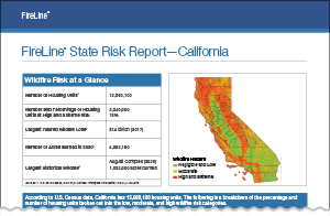
Verisk’s Wildfire Risk Analysis Reports, based on their Fireline wildfire risk management tool, provides analysis on the number and percentage of properties at high and extreme risk from wildfire in the most vulnerable western U.S. states. Registration required.